This article appeared in my local paper this week. It gives a good overview of the trip.
http://blog.cleveland.com/newssun/2011/10/berea_hiker_completes_170-day.html
Saturday, October 22, 2011
Monday, October 10, 2011
Links to the Channel 5 and MSNBC
A big thank you to everyone that came out to hear about my AT adventure and see my photos. I hope you enjoyed the evening as much as I did. Here are two links to the stories that appeared in the news recently. If you want to watch the story, use the first link. Copy and paste them into your browser.
http://www.newsnet5.com/dpp/news/local_news/67-year-old-man-hikes-entire-Appalachian-Trail-last-350-miles-with-a-broken-ankle
http://www.msnbc.msn.com/id/44726150/ns/local_news-cleveland_oh/#.TpMid7LLIqA
http://www.newsnet5.com/dpp/news/local_news/67-year-old-man-hikes-entire-Appalachian-Trail-last-350-miles-with-a-broken-ankle
http://www.msnbc.msn.com/id/44726150/ns/local_news-cleveland_oh/#.TpMid7LLIqA
Monday, September 26, 2011
Presentation
I will be making a presentation about my Appalachian Trail thru-hike. I expect to give a brief talk about the nearly 6-month hike, show my photos I took on the trail, and answer questions about the 2,200- mile adventure. This is will take place on Sunday, October 9 at 7:00 PM. It will be held at the Western Campus Theatre of Cuyahoga Community College at 11000 W. Pleasant Valley Road Parma, OH 44130. No need to RSVP--just come! Hope to see you all there.
Wednesday, September 21, 2011
A "BREAKING" Story
You will probably recall that on Thursday, July 28 I fell on a steep and treacherous rock descent on North Kinsman Mountain in the White Mountains of New Hampshire and twisted my ankle. I decided to call a retired Orthopedic Surgeon, Dr. Kim Brown, whom I had met just ten days earlier in Lake George, NY. Dr. Brown listened to me as I described the condition of my ankle over the phone. He said that I should have an xray to really know the condition of the ankle. However, he understood that an xray was not possible at that time. From what he could surmise by my description, he guessed that I probably had a severe ankle sprain. He suggested that I obtain an Air Cast Ankle Stirrup to use immediately and continue using it through the rest of my hike. I was able to purchase one by phone at a Rite-Aid Drug Store in Lincoln, NH. Lincoln was the closest town to where I was on the AT. Later the same day two AT hikers hiked five miles up and then five miles down the mountain to get it to me. After two days of rest and a small amount of walking on the tent pad where I had set up my tent, I resumed my hike. The Air Cast certainly stabilized the side-to-side movement of my ankle. Within a week after the injury the ankle felt much better. When I finished the hike, I seldom thought of the ankle.
I finished the hike on September 7. Two days later I called Dr. Brown. He thought it would be a good idea to still have an xray on the ankle even at that late date. Since I have been home the ankle is still slightly swollen and tender at times. Today I had an appointment with an orthopedic surgeon, Dr. Robert Coale. After an xray technician took three xrays of my ankle, I returned to await Dr. Coale. Within a few minutes the xray technician came to the room where I was awaiting the doctor. She had an expression of wonderment as she asked me if I knew that the ankle was broken. Obviously I did not!
When the doctor entered I told him my AT tale. He was quite surprised that I was able to continue hiking after just a few days of ankle rest, especially in the most rugged states of the AT-----New Hampshire and Maine. He said that I must have a high pain tolerance. I have never thought that I did. He described the break as an "Oblique Distal Fibula Fracture." He advised me not to jog or run for another four weeks. He described the break as clean and now mostly healed. He also said that in about four to six weeks the ankle should be fully healed and pretty much back to normal!
Now as I reflect on the whole episode I am glad that I didn't know that it was broken. If I had known, I most likely would have taken several weeks off and gone home. By now I would likely have been back on the trail still hiking. I believe that the old saying is true, "ALL IS WELL THAT ENDS WELL!"
I hope to have one more blog within a few weeks to give you some final thoughts about my AT hike. I'll be touch!
Wednesday, September 7, 2011
Victory!!
Tuesday (9-6) started at 9 AM as the hostel owner (Ole Man) shuttled us back to the Abol Bridge. Here is a view of Mt. Katahdin in the distance.
 We had lunch along the Nesowadnehunk Stream which was deep and furious. Fortunately, we didn't have to ford the stream because we wouldn't have been able to do so. It was at least chest-high. We reached Katahdin Stream Campsite at the base of the mountain at 2:15 PM. After paying $10 to camp we were able to get a two person lean-to. Chainsaw stayed in his tent and I shared a lean-to with Old Grand Dad. We hiked 9.9 miles. We were up early on Wednesday (9-7) to get our exciting day started. We started hiking up the mountain at 6 AM. The weather was cool and later in the morning it began to rain. As we proceeded up the mile high mountain, the temperature dropped and the wind picked up. We reached the summit at 11 AM.
 We took a few pictures and then started heading back down after 15 minutes. The wind chill felt like it was in the 30 degree range. It was a tough climb going up and coming back down. We got back to the ranger station at 4 PM. The AT Lodge owner shuttled us to Millinocket, ME for the evening. Tomorrow Deadman and I head to Bangor, ME in the morning and hopefully Acadia National Park in the afternoon if the weather is OK. We both fly home on Friday. I'm looking forward to getting home but it has been a GREAT adventure.
Thank you all so much for you kind wishes, prayers, and support. It's been a blessing to be able to share my journey with you.
Check back next week for a few exciting events that are set to take place!.


Thank you all so much for you kind wishes, prayers, and support. It's been a blessing to be able to share my journey with you.
Check back next week for a few exciting events that are set to take place!.
Tuesday, September 6, 2011
Winding Down
After breakfast in Monson on Saturday (9-3), we were shuttled back to Jo-Mary Rd where we started hiking at 9:45 AM. I was eager to begin the last section of the hike. Here is a picture of a sheer rock face with trees growing out the side and a lot of moss.
 We forded two streams. The first one required taking off our boots and socks and putting on our Crocs. The second stream had more rocks to use for crossing so we all decided not to change our shoes. The rocks were slippery and some were uneven. About 2/3 of the way across, I slipped and fell in. My right foot was caught between two rocks and the strong current made it difficult to stand upright. It took me about 30 seconds to get myself back in control of the situation in the waist-high water. Somehow, only the bottom of my backpack got wet. I keep my tent in the bottom of my bag so no real harm was done. Then I realized that one of my hiking sticks was missing. One stick floated away and I couldn't see it. Fortunately Deadman was still on the shore and he spotted out the pole below the surface about 50 feet downstream. I made it to land, took off my backpack, and went back in after it. Other than being very wet, the ordeal ended OK. We continued hiking until 6:30 PM when we tented just off the trail. Considering the late morning start, we were pleased to have hiked 15.0 miles. Sunday (9-4) started at 6:30 AM. Here is a picture of the misty morning in Maine.

We climbed 900 rocky feet to the top of Nesuntabunt Mountain, descended 900 feet to Pollywog Stream, and then had lunch at Rainbow Stream Lean-to. The morning was difficult with lots of mud and unending standing water. We forded one stream by rock hopping. The afternoon had easier terrain with no major climbs but still, lots of mud and water everywhere. At 3:30 PM we heard thunder in the distance and it kept creeping closer. As we reached Rainbow Spring Campground at 4:30 PM, the rain began so we quickly put up our tents. I ate dinner in my tent after I towel dried the floor due to all the water. The rain stopped at 6 PM for a few minutes so we all quickly walked to a nearby spring to get water. We hiked 14.7 miles. The goal of Monday (9-5) was to reach Abol Bridge. The overnight rain left all of us with wet tents and wet gear. The trail was very sloppy and drenched. We reached Abol Bridge at 2:30 PM. By 3 PM we were being shuttled to the Appalachian Trail Lodge, a hostel about 30 miles away in Millinocket, ME. It continued to pour all night and it is expected to continue into Tuesday. We hiked 11.2 miles so we are 15.2 miles from the peak of Mt. Katahdin. After 24 weeks (168 days), I have hiked 2,165.8 miles for an average of 12.9 miles per day. Hopefully the next post will be a picture of me on top of Mt. Katahdin!


We climbed 900 rocky feet to the top of Nesuntabunt Mountain, descended 900 feet to Pollywog Stream, and then had lunch at Rainbow Stream Lean-to. The morning was difficult with lots of mud and unending standing water. We forded one stream by rock hopping. The afternoon had easier terrain with no major climbs but still, lots of mud and water everywhere. At 3:30 PM we heard thunder in the distance and it kept creeping closer. As we reached Rainbow Spring Campground at 4:30 PM, the rain began so we quickly put up our tents. I ate dinner in my tent after I towel dried the floor due to all the water. The rain stopped at 6 PM for a few minutes so we all quickly walked to a nearby spring to get water. We hiked 14.7 miles. The goal of Monday (9-5) was to reach Abol Bridge. The overnight rain left all of us with wet tents and wet gear. The trail was very sloppy and drenched. We reached Abol Bridge at 2:30 PM. By 3 PM we were being shuttled to the Appalachian Trail Lodge, a hostel about 30 miles away in Millinocket, ME. It continued to pour all night and it is expected to continue into Tuesday. We hiked 11.2 miles so we are 15.2 miles from the peak of Mt. Katahdin. After 24 weeks (168 days), I have hiked 2,165.8 miles for an average of 12.9 miles per day. Hopefully the next post will be a picture of me on top of Mt. Katahdin!
Saturday, September 3, 2011
High Water
Because of Hurricane Irene, the brooks and rivers we needed to cross on Tuesday (8-30) were flooded. We changed our plans around a bit so we were shuttled 52 miles into the 100-mile wilderness and dropped off on the trail at a logging road called Jo-Mary Rd. We started hiking south back to Shaw's Lodging in Monson. By doing this we could avoid some of the high water until it had a chance to recede a little bit. It took 1 hr and 45 minutes to reach Jo-Mary Rd. We started hiking at 10 AM. There was only one mountain to climb--Little Boardman Mountain. We forded the East Branch Pleasant River which was waist-deep with a fairly strong current. The water came up to the bottom of my backpack so my gear got a little wet. We hiked until 7:15 PM in order to maximize our miles since we got a late start due to the almost two hour shuttle ride. We were able to go 15.4 miles. Wednesday (8-31) was a cool and dry day. We were back out on the trail at 6:45 AM and we immediately climbed 1,100 feet to the top of White Cap Mountain (elev. 3,650). Then we tackled Hay Mountain and Gulf Hagas Mountain. We forded the West Branch Pleasant River and it was about waist-high too. We finished at 6 PM and went 14.4 miles. Thursday (9-1) could have been called "Mountain Climbing Day" as we started by climbing Chairback Mountain. This was the correct path going up if you want to call it a path!
 Next was Columbus Mountain, then Monument Cliff at the top of Third Mountain, then Fourth Mountain (it is actually called that), and finally Barren Mountain. Each time there was a steep descent before climbing again. We finished at 6:15 PM. It was a very tough day. We were able to go 13.6 miles because there weren't any streams to cross. Friday (9-2) was another beauty of a day. There weren't any major mountains to climb but there were plenty of ups and downs of hundreds of feet at a time. We forded three streams--Long Pond Stream (thigh-high), Big Wilson Stream (knee-high), and Little Wilson Stream (calf-high). It is refreshing to ford a stream with cold water but it is time consuming. You have to take off your boots and socks, secure them on your backpack, get your Crocs out, ford the stream, dry your feet off, put the boots and socks back on and then put your Crocs away. It is a production and it takes at least 15 minutes just to go a very short distance. A hostel representative met us at 2 PM at a road access and took us back to Monson. After a quick resupply, we are now ready to hike north on Saturday from Jo-Mary Rd which is 56.1 miles from Mt. Katahdin. We hiked 8.5 miles. It is hard to believe we are almost there!

Friday, September 2, 2011
Almost Done....
I'm excited to tell you that I have a date to climb Mt. Katahdin, the northern terminus of the AT! We (there are now five of us) expect to summit on
Wed., Sept. 7 with a rain date of Thurs., Sept. 8. I have a one-way plane ticket from Bangor, ME to Cleveland, OH for Fri., Sept. 9.
Wed., Sept. 7 with a rain date of Thurs., Sept. 8. I have a one-way plane ticket from Bangor, ME to Cleveland, OH for Fri., Sept. 9.
Tuesday, August 30, 2011
Hurricane Irene
Friday (8-26) started at 6:15 AM on yet another gorgeous day. We climbed Pleasant Pond Mountain (2,470 ft). We had lunch near the top of the mountain as we were just about to begin the 1,500 foot descent. We had forded (crossed) several bodies of water before but when we reached Baker Stream, we needed to take off our boots and socks and put on our Crocs in order to get across. The stream was knee-deep with a reasonably strong current. We finished at 4:30 PM when we tented at Bald Mountain Brook Lean-to (shelter). We hiked 14.7 miles. We were back hiking at 6:30 AM on Saturday (8-27) and it was another beautiful day. The weather has been amazing for several days and it has been such a blessing. The terrain was flat but as usual it was muddy, rocky, and filled with large tree roots. We forded two more bodies of water. The water at the Bald Mountain Pond was mid-calf level and the water at the West Branch Piscataquis River was knee-deep. I took this picture from the top of Moxie Bald Mountain. The clouds were very low-lying.

We began the tricky 1,700 ft. descent. We reached our hiking goal when we got to Horseshoe Canyon Lean-to at 3:30 PM. I set up my tent while Pilgrim and Deadman decided to stay in the lean-to. Upon hearing the weather forecast, I changed my mind and joined them in the lean-to. The rain and wind from Irene started overnight. Somewhere around 9 PM we heard a very loud BANG. A large tree branch fell on the metal roof. In the morning, we could see a very big dent in the roof. Thankfully everyone in the lean-to was fine even though it scared us. We hiked 13.0 miles. We started on Sunday (8-28) at 6:15 AM in the rain. We wanted to get an early start since we knew bad weather from Irene was quickly coming our way. Due to the rain we were very concerned about fording the East Branch Piscataquis River. The hiking guide indicated it to be dangerous after a lot of rain. We were relieved that so far the water was only at mid-calf level. Just 24 hours later, we heard it is now more than three feet deep and thus, impassible for now. The overnight rain made the trail very slippery and muddier than usual. We arrived at Route 15 at 11:30 AM and we were shuttled to Shaw's Lodging in Monson (pop. 500). Monson marks the beginning for the 100-mile wilderness. We are getting relatively close to our final goal of Mt. Katahdin. We hiked 9.0 miles. After breakfast at Shaw's on Monday (8-29) the hostel owner took us back to the trail. We hiked south 10 miles back to Route 15 where we left the trail on Sunday. This "flip-flop" allowed us to stay a second night at the hostel due to the weather. We forded Leeman Brook which had risen from Irene. It usually is only a trickle but now it was mid-calf and rushing. The trail in many places resembled a small creek. After 161 days (23 weeks) I've hiked 2,076.4 miles for an average of 12.9 miles per day. I hope to be done within the next 10 days or so!

We began the tricky 1,700 ft. descent. We reached our hiking goal when we got to Horseshoe Canyon Lean-to at 3:30 PM. I set up my tent while Pilgrim and Deadman decided to stay in the lean-to. Upon hearing the weather forecast, I changed my mind and joined them in the lean-to. The rain and wind from Irene started overnight. Somewhere around 9 PM we heard a very loud BANG. A large tree branch fell on the metal roof. In the morning, we could see a very big dent in the roof. Thankfully everyone in the lean-to was fine even though it scared us. We hiked 13.0 miles. We started on Sunday (8-28) at 6:15 AM in the rain. We wanted to get an early start since we knew bad weather from Irene was quickly coming our way. Due to the rain we were very concerned about fording the East Branch Piscataquis River. The hiking guide indicated it to be dangerous after a lot of rain. We were relieved that so far the water was only at mid-calf level. Just 24 hours later, we heard it is now more than three feet deep and thus, impassible for now. The overnight rain made the trail very slippery and muddier than usual. We arrived at Route 15 at 11:30 AM and we were shuttled to Shaw's Lodging in Monson (pop. 500). Monson marks the beginning for the 100-mile wilderness. We are getting relatively close to our final goal of Mt. Katahdin. We hiked 9.0 miles. After breakfast at Shaw's on Monday (8-29) the hostel owner took us back to the trail. We hiked south 10 miles back to Route 15 where we left the trail on Sunday. This "flip-flop" allowed us to stay a second night at the hostel due to the weather. We forded Leeman Brook which had risen from Irene. It usually is only a trickle but now it was mid-calf and rushing. The trail in many places resembled a small creek. After 161 days (23 weeks) I've hiked 2,076.4 miles for an average of 12.9 miles per day. I hope to be done within the next 10 days or so!
Friday, August 26, 2011
Enjoying Maine
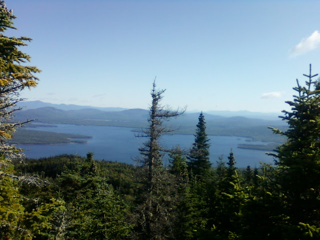
Monday (8-23) was yet another beautiful day. We have been very blessed with the abundance of nice weather recently. After climbing 800 ft to the East Peak of the Little Bigelow Mountain, we had lunch at the lean-to at 1 PM. We descended 1,800 ft to the serene Flagstaff Lake where I took a short nap. Here is the lake.
At 2 PM we continued hiking and we reached the 2,000 mile mark painted on the road. Because the AT gets slightly longer each year due to some relocation of the trail, we had already hiked 2,012.2 miles. We climbed Roundtop Mountain and then we arrived at West Carry Pond Lean-to at 5:00 PM where we set up our tents. After dinner we heard the sound of a loon on the large pond. Overall it was an easy day of hiking and we traveled 12.2 miles. Tuesday (8-24) started at 7 AM for us. The trail was relatively flat with neither long climbs nor steep descents. There was still an overabundance of roots, rocks, and mud. Elevation change for the day varied no more than 200 ft at a time. We enjoyed lunch sitting on a large log directly on the trail. We reached Pierce Pond Lean-to at 2:00 PM and set up the tents. It was a welcome change to be done hiking early in the day. I was able to write my daily blog in the daylight and not feel rushed. The ponds in Maine, like Pierce Pond, are huge--hundreds of acres. They are surrounded by trees and the area is as gorgeous as you would imagine. We started on Thursday (8-25) at 6:30 AM. We hiked .4 miles to have breakfast at Harrison Pierce Pond Camps, a traditional camp for vacationers and anglers. The camp was built in 1934 and is very rustic and decorated with a sportsman flair. The owner cooked us an amazing feast. I had 10 blueberry pancakes, eggs, sausage, coffee, and juice! Within five minutes of leaving Harrison's, we saw our first moose about 90 ft away in a stream as we were hiking to the Kennebec River. Wow, what a HUGE animal! The Kennebec River is the most formidable unbridged crossing on the AT. A thru-hiker drowned in 1985 trying to ford the river and many others have had close calls. The river spans 150 yards and is up to six feet deep. Dangers include rocks, strong currents, and unpredictable water levels due to releases to the dam upstream. Hikers are urged not to attempt to ford the river. The ferry (a canoe) is the official route and even has a white blaze painted on the bottom of it. Over the last 20+ years the canoe has ferried in excess of 20,000 hikers. After we crossed, we hiked to US 201 where we were picked up and driven two miles to the lodge where we sent our food earlier in this week. We did the usual--showered, did laundry, and had dinner. I can see why people who love the outdoors appreciate the beauty of Maine.

At 2 PM we continued hiking and we reached the 2,000 mile mark painted on the road. Because the AT gets slightly longer each year due to some relocation of the trail, we had already hiked 2,012.2 miles. We climbed Roundtop Mountain and then we arrived at West Carry Pond Lean-to at 5:00 PM where we set up our tents. After dinner we heard the sound of a loon on the large pond. Overall it was an easy day of hiking and we traveled 12.2 miles. Tuesday (8-24) started at 7 AM for us. The trail was relatively flat with neither long climbs nor steep descents. There was still an overabundance of roots, rocks, and mud. Elevation change for the day varied no more than 200 ft at a time. We enjoyed lunch sitting on a large log directly on the trail. We reached Pierce Pond Lean-to at 2:00 PM and set up the tents. It was a welcome change to be done hiking early in the day. I was able to write my daily blog in the daylight and not feel rushed. The ponds in Maine, like Pierce Pond, are huge--hundreds of acres. They are surrounded by trees and the area is as gorgeous as you would imagine. We started on Thursday (8-25) at 6:30 AM. We hiked .4 miles to have breakfast at Harrison Pierce Pond Camps, a traditional camp for vacationers and anglers. The camp was built in 1934 and is very rustic and decorated with a sportsman flair. The owner cooked us an amazing feast. I had 10 blueberry pancakes, eggs, sausage, coffee, and juice! Within five minutes of leaving Harrison's, we saw our first moose about 90 ft away in a stream as we were hiking to the Kennebec River. Wow, what a HUGE animal! The Kennebec River is the most formidable unbridged crossing on the AT. A thru-hiker drowned in 1985 trying to ford the river and many others have had close calls. The river spans 150 yards and is up to six feet deep. Dangers include rocks, strong currents, and unpredictable water levels due to releases to the dam upstream. Hikers are urged not to attempt to ford the river. The ferry (a canoe) is the official route and even has a white blaze painted on the bottom of it. Over the last 20+ years the canoe has ferried in excess of 20,000 hikers. After we crossed, we hiked to US 201 where we were picked up and driven two miles to the lodge where we sent our food earlier in this week. We did the usual--showered, did laundry, and had dinner. I can see why people who love the outdoors appreciate the beauty of Maine.
Tuesday, August 23, 2011
New Boots and the 2,000 Mile Mark
We started our hike on Saturday (8-20) at 7:10 AM on yet another gorgeous day. We climbed S. Crocker Mountain (4,039 ft), descended 400 ft, and then climbed N. Crocker Mountain at 4,228 ft. We began a 2,800 ft descent over the course of five miles to reach Stratton, ME. We got a ride at the trailhead to the Stratton Motel. We did our laundry and enjoyed dinner after hiking 8.4 miles for the day. On Sunday (8-21) we took a zero hiking day. We had breakfast at a diner across from the motel and then resupplied at a grocery store next door. We bought enough food to last us for four days which will get us into Caratunk, ME. We also bought an additional four days worth of food and sent it to Caratunk to get us from Caratunk to Monson, ME. Caratunk doesn't have a grocery store. We will pick up our food shipment at a lodge on Thursday evening. My Scarpa boots are finally shot.
 These excellent boots took me 2,000 miles but unfortunately, won't take me to the end. They have fallen apart and the tred on the bottom is very worn. After lunch the motel owner drove us to Rangeley, ME so I could go to an outfitter and purchase new boots. I bought Merrell hiking boots this time. On Monday (8-22) the motel owner drove us back to the trail at 7 AM. There was a lot climbing as we crossed three peaks of the Bigelow Mountains: South Horn (3,831), West Peak (4,145), and the Avery Peak (4,090). After the initial ascent to the South Horn, we descended 600 ft. each time before finally reaching Avery Peak. The sun was shining and it was nice outside when we reached the top of the South Horn. This is the West Peak.
 When we reached the second and third peaks, the weather quickly changed to cold and windy and a light rain started. A jacket was essential. We camped at 5 PM after hiking 10.4 miles. After 154 days (22 weeks) I have hit the 2,000 mile mark! I have hiked 2,003.5 miles for an average of 13.0 miles per day.


Saturday, August 20, 2011
Under 200 Miles To Go!
Tuesday (8-16) was a rainy morning. The hostel owner drove us back to the trail at 8 AM. We started with wet feet from the day before. With two days of rain, the AT resembled a creek rather than a trail. The trail was muddy, slippery, and ugly. The roots were wet and to be avoided at all cost. Roots are enemy number one because it is so easy to trip over even a small one, if you aren't watching your every step. We climbed Old Blue Mountain with an elevation of 3,600 ft. There were plenty of rock scrambles, bars, and ladders. Bars and ladders are permanently cemented on some of the big boulders so you can get up and over the rocks. After a long and difficult descent we climbed Bemis Mountain. We were glad to see the day end at
5 PM when we reached the Bemis Mountain Lean-to. We hiked 8.7 miles. Wednesday started out at 7 AM on a nice day. The morning was difficult with a steep descent of 1,300 ft and then immediately an ascent of 1,000 ft. Again, bars and ladders were necessary several times. The afternoon was easier than the morning so that was a treat. We reached a campsite at 5:30 PM where we tented for the night. We went 12.9 miles. Thursday was another pleasant day. We climbed over Saddleback Mountain in the afternoon. Here is the beautiful view from the top of the mountain.

Next up was The Horn Mountain. Both are 4,000+ ft mountains. We had breathtaking views of Maine in all directions. Then we descended into Redington Stream Campsite at 5 PM where we tented. We were the only hikers there. Maine is a great state for R&R--not rest and relaxation but roots and rocks! We hiked 13.2 miles. We were blessed again on Friday with yet another beautiful day. This was the fourth day in a row of good weather, which is unusual. The day started with climbing Saddleback Junior Mountain. It is called Junior because the elevation is "only" 3,655 ft vs Saddleback being 4,120 ft. We had an early lunch at 11 AM at a stream we forded. So far we have successfully forded three with seven to go. The mud is still a slight problem but far better than earlier in the week. At 3 PM we stopped at Spaulding Mountain Shelter. We decided to eat and take a short rest. We resumed hiking at 4 PM and hiked 5.1 more miles to make it easier for us to reach Stratton, Maine on Saturday afternoon. We finally finished our hiking day at 7:45 PM and completed 15.4 miles. We have 196.3 miles until the end!
Monday, August 15, 2011
Pilgrim's Leg Infection and Trail Food
Friday (8-12) started for us at 6:40 AM with a steep 500 ft climb and several rock scrambles, all while there was a swirling 50 mph wind. It was misty with poor visibility. We descended 2,500 ft before we climbed back up 2,300 ft over Baldpate Mountains East and West. I took this picture from Baldpate West while I was looking back at Baldpate East.

We finally descended 1,500 ft to Frye Notch Lean-to (shelter) where we tented after going 10.4 miles. We started our day on Saturday at 7 AM on a cool day. We reached East B Hill Road where the Pine Ellis Hostel picked us up at 10:45 AM. We showered, did laundry, and had lunch at a general store. Pilgrim had a large (size of a softball) red area on his leg with a small cut in the middle. We stopped at a pharmacy and the pharmacist looked at his leg and advised him to see a doctor. In the late afternoon, he went to the hospital and he arrived back to the hostel at 10 PM. He felt much better after his IV antibiotic treatment. On Sunday (8-14) we expected to start hiking in the morning but that didn't happen. When Pilgrim was at the hospital on Saturday, the doctor told him to come back on Sunday for a second round of the IV antibiotic. He will also take an oral antibiotic for several more days. All three of us have had different health problems on the trail. I had the injured ankle, Pilgrim had the leg infection, and Deadman suffered hypothermia back in Georgia. When Deadman got to Mountain Crossings Hostel in Blairsville, GA at Neel's Gap, all his gear had been wet for two full days. He stumbled into the hostel and he immediately was given a bed to rest. The hostel operator told the other hikers, "There is a dead man in there." Hence, the trail name Deadman was born. On Monday (8-15) the hostel owner shuttled us back to the AT at 7 AM. Soon after the hike began, the rain started and it didn't quit all day. The trail was wet, muddy, rocky, and as slippery as ice. Everyone fell at least once. When we finally reached S. Arm Road at 3:15 PM, the same hostel owner picked us up once again. We hiked 10.1 miles. After 21 weeks (147 days) I have hiked 1,934.5 miles for an average of 13.2 miles per day. We have 246.5 miles until the end. I hope to be done and back home in Ohio by the middle of September.
Some people have asked me what I eat on the trail. When I first started hiking, I "cooked" in the evening. I made mashed potatoes, Mountain House freeze dried dinners which are dehydrated meals, like astronaut food, and Knorr packaged foods. After two months of doing this, I no longer felt the need for a hot meal since the weather was quickly heating up. At the end of May, I sent my stove and pan home. Now I live on peanut butter/Nutella and cheese on a bagel with every meal. At breakfast I drink two packages of Carnation Breakfast Essentials, formerly Carnation Instant Breakfast. At lunch and dinner I drink Crystal Light lemonade and have Oreos for dessert. I also eat dried fruits, Snickers, and various energy/granola bars. Of course, I look forward to going to a restaurant when the opportunity comes up. When we are on the trail, we typically take about a 40 minute lunch break and a few five minute breaks throughout the day. The rest of the time--surprise, surprise, we hike!
Friday, August 12, 2011
Maine
I started hiking on Tuesday (8-9) at 6:20 AM after breakfast at the hostel. I climbed Mount Hayes (2,555 ft) and then Cascade Mountain. (2,631). The climbs were not as tough as the White Mountains but tough enough. I was glad to get to Gentian Pond Shelter at 4 PM. It is nice to have friends to hike with again. I hiked 11.8 miles. We started the day on Wednesday (8-10) at 6:40 AM. It rained for most of the day which makes things that much more difficult. We were either climbing or descending over slippery rocks, mud, and roots all day. Each of us fell numerous times but thankfully no one was hurt. At 10:30 AM we entered Maine, the 14th and last state on the trail!

As you can see from the sign, it is 281.4 miles to reach Mt. Katahdin, the end of the AT. Maine is second in the number of miles on the trail with only Virginia having more. We went over Goose Eye Mountain and had numerous rock scrambles. We had heard from several other hikers that southern Maine is as tough or tougher than the White Mountains were in New Hampshire. We finally finished a challenging day at 7:10 PM and completed 9.5 miles. We got a late start on Thursday (8-11) as we wanted to make sure the weather was favorable. We entered the much talked about Mahoosuc Notch. For 1.1 miles the AT climbs over, crawls under, squeezes between, slides down, and jumps huge rocks. There were many times the terrain looked impassible when I first glanced. Many of the ascents are actually rock climbing and someone would be seriously hurt if he/she fell. At times we had to pass our backpacks between each other just to get through the rock obstacles. This section is notoriously known as the toughest mile on the entire trail. It took us more than 3 hours just to go 1.1 miles. Here is a picture where there is ice/snow between the rocks, even in August!

We reached Speck Pond Shelter at 5:30 PM and the three of us tented on a group tent pad. We hiked only 5.1 miles over nine hours but we have now finished one of the most difficult sections of the AT.
Tuesday, August 9, 2011
Hiking Again with "Pilgrim" and Now "Deadman" Too
This is how I spent my day on Friday (8-5)--hiking over rock, after rock, after rock. This is the trail, believe it or not, and it was like this for almost the entire seven miles. It seemed like 21 miles though. It was the most physically and mentally exhausting day since I started in Georgia back in March.
 I was so glad to finally reach the hut and be done for the day. I expected to do kitchen work at Madison Spring Hut for my work-for-stay obligation. Instead, the hut manager asked me give a talk to guests/vacationers on thru-hiking the AT. I spoke for about 10 minutes and then answered several questions. People were very attentive and seemed to be quite interested. Several people told me they thoroughly enjoyed it. I slept on an air mattress on the floor again as did two other hikers who also did work-for-stay. I started hiking on Saturday (8-6) at 6 AM and went from the hut (4,300 ft) and over and down Mount Madison (5,366 ft). Here is a picture looking back after I had already climbed it. You can see the narrow dirt path in the front of the picture. That is the AT.

When I reached Pinkham Notch, I was picked up by a hostel shuttle. When Pilgrim and Deadman finally arrived at the hostel, I was able to surprise them! They have been hiking together since I got hurt on July 28 and they were really happy to see me. Deadman is a great guy about my age who lives in Georgia. They had planned a zero hiking day for Sunday and agreed to take another zero day on Monday so I could catch up with them since I was two hiking days behind. The three of us hope to finish the AT together. Pray that this happens! In the evening we resupplied and enjoyed dinner while we rehashed what has happened since we had last seen each other. I hiked 7.8 miles. On Sunday (8-7) the hostel shuttle took me back to Pinkham Notch at 8 AM to resume my hike. I hiked from Pinkham Notch (2,050 ft) on a rainy and dark day up Wildcat Mountain (4,422 ft). I had to rock scramble (rock climb, use my hands) the entire way. In one very precarious scramble position, in my head I could hear my deceased mother say, "Bobby, get down from there!" I thought to myself, "I'd be glad to!" I descended to Carter Notch Hut (3,350 ft) for lunch and then climbed Carter Dome (4,832 ft). Again, I went 7.8 miles. I started hiking at 6 AM on Monday (8-8). Rain started mid-morning and continued intermittently for several hours. I descended to 3,915 ft, climbed back up to 4,618 ft, descended again to 3,100 ft, and then climbed to 4,000 ft. My final descent of the day was to 780 ft when I reached the hostel at 4:45 PM. I hiked 13.3 miles. After 20 weeks (140 days) I have hiked 1,880.4 miles for an average of 13.4 miles per day. Once again my ankle is getting a little bit better with each passing day. I hope it is 100% soon. I plan to wear the ankle brace for extra support all the way to the end of the trail--300 more miles! I'll be entering Maine, the last state on the AT, on Wednesday (8-10).


When I reached Pinkham Notch, I was picked up by a hostel shuttle. When Pilgrim and Deadman finally arrived at the hostel, I was able to surprise them! They have been hiking together since I got hurt on July 28 and they were really happy to see me. Deadman is a great guy about my age who lives in Georgia. They had planned a zero hiking day for Sunday and agreed to take another zero day on Monday so I could catch up with them since I was two hiking days behind. The three of us hope to finish the AT together. Pray that this happens! In the evening we resupplied and enjoyed dinner while we rehashed what has happened since we had last seen each other. I hiked 7.8 miles. On Sunday (8-7) the hostel shuttle took me back to Pinkham Notch at 8 AM to resume my hike. I hiked from Pinkham Notch (2,050 ft) on a rainy and dark day up Wildcat Mountain (4,422 ft). I had to rock scramble (rock climb, use my hands) the entire way. In one very precarious scramble position, in my head I could hear my deceased mother say, "Bobby, get down from there!" I thought to myself, "I'd be glad to!" I descended to Carter Notch Hut (3,350 ft) for lunch and then climbed Carter Dome (4,832 ft). Again, I went 7.8 miles. I started hiking at 6 AM on Monday (8-8). Rain started mid-morning and continued intermittently for several hours. I descended to 3,915 ft, climbed back up to 4,618 ft, descended again to 3,100 ft, and then climbed to 4,000 ft. My final descent of the day was to 780 ft when I reached the hostel at 4:45 PM. I hiked 13.3 miles. After 20 weeks (140 days) I have hiked 1,880.4 miles for an average of 13.4 miles per day. Once again my ankle is getting a little bit better with each passing day. I hope it is 100% soon. I plan to wear the ankle brace for extra support all the way to the end of the trail--300 more miles! I'll be entering Maine, the last state on the AT, on Wednesday (8-10).
Thursday, August 4, 2011
Lots of Elevations and the Ankle is Improving!
The shuttle picked up several hikers at Chet's Hostel on Monday (8-1) and took us to Franconia Notch. It was a long day of hiking that lasted from 7:10 AM-7:45 PM. Franconia Notch has an elevation of 1,450 feet. I climbed Little Haystack Mountain (4,800 ft) where I had lunch on a rock. I then climbed over Mt. Lincoln (5,089 ft) and finally over Mt. Lafayette (5,260). I stealth camped (made my own campsite) at Garfield Pond (3,860 ft). I went 9.2 miles on a dry day although rain was in the forecast. I started hiking on Tuesday (8-2) at 7 AM when I rock scrambled (had to use my hands to get up the mountain) Mt. Garfield (4,500 ft). The descent down to the Galehouse Hut (3,800 ft) where I had lunch was super steep and rugged. I continued to rock scramble all day. Rain continued on and off until evening. During the afternoon I climbed over the South Twin Mountain (4,902 ft) and descended to Mt. Guyot (4,580 ft) soon after. I stealth camped just inches off the trail. Unfortunately I had to put my tent up in the rain--not fun! I went 8.6 miles. I started hiking at 7:30 AM on Wednesday (8-3). Packing wet clothes and my wet tent was difficult as I was trying to keep the rest of my gear dry. Again, I had to do lots of rock scrambling and then it suddenly turned relatively flat and rock free-it was great! I made it to Saco River (1,277 ft) and I began to partially climb the Webster Cliffs. I stealth camped again just inches from the trail. I went 11.0 miles. On Thursday (8-4) I started at 6:30 AM and finished going over the Webster Cliffs (3,350 ft) and then I tackled Mt. Webster (3,910 ft) followed by Mt. Jackson (4,052 ft). In the afternoon I climbed Mt. Pierce (4,312 ft) and then Mt. Franklin (5,004 ft). I finally reached Lake of the Clouds Hut (shelter) at 4 PM and I was able to get a work-for-stay arrangement. Normally, someone staying at the hut pays $90, which includes dinner and breakfast. I'll sleep in the hut on the floor on my air mattress and have dinner and breakfast. In return, I'll wipe up the tables after dinner--easy! There are only four "jobs" available at this hut. I hiked 10.0 miles.
My injured ankle has slowly been improving each day, which has been a huge blessing. The pain has subsided but it is still quite weak. I pray it continues to heal and that I don't fall and hurt it again.
My injured ankle has slowly been improving each day, which has been a huge blessing. The pain has subsided but it is still quite weak. I pray it continues to heal and that I don't fall and hurt it again.
Tuesday, August 2, 2011
Slowly Moving Ahead
After a rainy night on Friday, Saturday morning (7-30) was damp, windy, and cold. Two southbound hikers brought my Aircast brace to me. They were at the same hostel in Lincoln, NH where I called for help and where I had stayed last week. The Aircast gives my ankle extra support and restricts side-to-side movement. I spent at least an hour walking with the cast on at the campsite. It definitely helps but the ankle is still tender and weak. I walked about 1/4 the speed of a normal person. Later in the afternoon my food request of a bag of bagels was met as yet another hiker arrived with them. The hiking community is like a second family to me and we try to help each other as much as possible. After 2 1/2 days of no hiking, I began hiking on Sunday (7-31) at 6:15 AM. Much of the trail was steep with rugged descents and unfortunately, it is going to be this way for the rest of the journey. The time when I need to be 100% is now so I am trying to keep moving but very slowly and carefully. I reached Franconia Notch at 1 PM and Chet's Hostel at 1:30 PM. I hiked 4.8 miles.
Saturday, July 30, 2011
Injury
On Tuesday (7-26) I took my first zero day of hiking since my family visited 50 days ago in Harpers Ferry, West Virginia. We had breakfast at at local pancake restaurant. Pilgrim made an afternoon medical appointment for his pulled muscle. We resupplied and did laundry and then parents of a hiker drove two hours to the hostel and brought everyone deli meats and cheese, rolls, pop, fruit, and chocolate bars. It was an unexpected lunch (trail magic) for all eight hikers who were there. On Wednesday (7-27) the shuttle picked us up on a cloudy and cool day. We resumed our hike at 7AM at Kinsman Notch in the White Mountains of NH. We had a 1,600 foot rocky and steep climb over Mount Wolf. Pilgrim is better but his leg is still bothering him. He didn't want to continue climbing since we were about to face a 2,100 foot ascent over the very difficult Kinsman Mountain. We stopped hiking at 2 PM and took a two hour nap. We hiked 7.5 miles for the day. Our day on Thursday (7-28) began on a cool morning. We had heard how difficult it was to get over the Kinsman Mountain due to the extreme terrain. We had to use our hands many times but we finally reached the summit by 10:30 AM. Here is one view.

Unfortunately when I was coming down, I fell on the steep rock descent and twisted my ankle. I hobbled down a little ways to Kinsman Pond Shelter and Campsite. Another thru-hiker (Dead Man) helped me by carrying my backpack. The caretaker at the campsite gave me cold water for the swollen ankle and she wrapped it in a bandage. I was able to set up my tent and elevate the ankle for a few hours. I can walk on it but hiking in rough terrain will be a problem in the near future. I'm taking Ibuprofen to treat the inflammation. My ankle was moderately swollen in the morning on Friday (7-29). I decided to call a retired orthopedic doctor, Dr. Kim Brown, for advice on my ankle. I met him 10 days ago when Pilgrim and I were in Lake George, New York. I described the condition of my ankle and Dr. Brown thought I had a moderate to severe strain. He suggested I walk on a flat surface for several minutes and then gradually increase the duration of the walk as my ankle improves. He also suggested the Aircast ankle brace to stabilize the side-to-side movement. I ordered the brace by phone from a pharmacy in Lincoln, New Hampshire. I’m hoping a thru-hiker who is in Lincoln can bring it to me on Saturday. I urged Pilgrim to continue his hike this morning since I may not start to hike again for a few days or possibly longer. He reluctantly agreed. I am hoping to catch up with him in either northern New Hampshire or southern Maine. Pray my ankle will heal and I'll be able to continue soon.

Unfortunately when I was coming down, I fell on the steep rock descent and twisted my ankle. I hobbled down a little ways to Kinsman Pond Shelter and Campsite. Another thru-hiker (Dead Man) helped me by carrying my backpack. The caretaker at the campsite gave me cold water for the swollen ankle and she wrapped it in a bandage. I was able to set up my tent and elevate the ankle for a few hours. I can walk on it but hiking in rough terrain will be a problem in the near future. I'm taking Ibuprofen to treat the inflammation. My ankle was moderately swollen in the morning on Friday (7-29). I decided to call a retired orthopedic doctor, Dr. Kim Brown, for advice on my ankle. I met him 10 days ago when Pilgrim and I were in Lake George, New York. I described the condition of my ankle and Dr. Brown thought I had a moderate to severe strain. He suggested I walk on a flat surface for several minutes and then gradually increase the duration of the walk as my ankle improves. He also suggested the Aircast ankle brace to stabilize the side-to-side movement. I ordered the brace by phone from a pharmacy in Lincoln, New Hampshire. I’m hoping a thru-hiker who is in Lincoln can bring it to me on Saturday. I urged Pilgrim to continue his hike this morning since I may not start to hike again for a few days or possibly longer. He reluctantly agreed. I am hoping to catch up with him in either northern New Hampshire or southern Maine. Pray my ankle will heal and I'll be able to continue soon.
Wednesday, July 27, 2011
On Saturday (7-23) our taxi arrived at the motel at 6:30 PM to take us 2 ½ miles back to the AT in Hanover. We had climbs of 400, 600, 900 and 1,000 feet. Our major concern was availability of water as several water sources were dry. The weather was hot, in the 90’s. We had lunch at the Moose Mountain Shelter and napped for 50 minutes. We completed our 16.6 mile hike at 6:15. We started our day on Sunday (7-24) at 6:40 AM on a great day weather wise – cooler and less humid. Our main concern again was water shortage. At the start of the day I carried 3 liters (6 pounds) rather than the 2 liters (4 pounds). We had climbs of 900, 1,500 and 2,300 feet. We finished our 19.1 mile hike at 6:30 PM. Once again we hiked for nearly 12 hours. We camped at the Ore Hill Shelter. On Monday (7-25) we began hiking at 6:45 AM. We went to the Beaver Brook Shelter and refilled our water containers. I treat non-spring water (creeks, streams, brooks, rivers, ponds etc.) with Aquamira. It kills bacteria and is widely used by hikers. After lunch we began a 3,800 foot climb at Mount Moosilauke. Going up and over the 4,800 foot mountain is a real challenge due to continuous climbing of nearly 3 hours over a steep and rocky terrain. We made it with just two five minute breaks for water. As we approached the top, the weather got colder and windier. At the summit the wind was about 50 MPH. We began our descent on the northern side at 3:00 PM and finally reached the bottom at 6:30 PM. It was a difficult descent on wet rocks and required the use of hand bars. An additional problem was that Pilgrim was hurting from a thigh muscle pull that occurred going up the mountain. He fell twice coming down the mountain and had swelling on his arm and leg. At the bottom of the mountain we reached Kinsman Notch. We called for a shuttle and were driven about five miles to One Step at a Time Hostel in Lincoln, New Hampshire. There were about 20 hikers there. Most of us slept on the floor of the garage as there were only six bunk beds. I was thankful for my Therm-A-Rest air mattress. We hiked 17.0 miles for the day. After 18 weeks (126 days) I have hiked 1,789.3 miles for an average of 14.2 miles a day. There is now less than 400 miles to reach Mount Katadhin in Maine!
Monday, July 25, 2011
Hanover, New Hampshire
After a relaxing and fun day on Tuesday (7-19) on Lake George, we were driven an hour back to the AT. We began our hike at 7:50 AM. It was a difficult day of hiking with a 2,500 foot climb over endless rocks and tree roots. In the morning we reached a sign which indicated we were 500 miles from Mount Katahdin, the northern terminus of the AT! Below the sign was trail magic – lots of ice cold drinks. At the end of our hiking day, the AT split from the Long Trail. We tented at Tucker-Johnson Shelter Campsite. We hiked 18.4 miles for the day. On Wednesday (7-20) we began our hike at 6:15 AM. We reached Gifford Woods State Park in Vermont by mid-morning. I heard someone say “Buckeye” and I turned to see two hikers who I had talked with back in Virginia and then in Pennsylvania. A little while later we reached Thundering Falls. As you can see, it was beautiful!

We had a 1,200 foot climb over Quimby Mountain before lunch at the Stony Brook Shelter. In the afternoon we crossed a road and I saw a house nearby. I went to the house and found no one home. I was nearly out of water so I filled my CamelBak with water out of their hose! About 6 PM we reached Winturri Shelter and tented. We hiked 18.9 miles for the day. Thursday (7-21) was a 98 degree day with high humidity. We began our hike at 6:40 AM. The climbs for the day were moderate with 600, 700, and 1000 foot elevations. We had lunch just off the AT at a place that sold ice cream and drinks. We each bought a pint of vanilla ice cream and a bottle of root beer to make root beer floats. We ate at a picnic table in the shade with a great breeze. It was the only cool part of the day! After lunch I called Joe Stagliano, brother of Dick Stagliano. Dick is a friend who started teaching with me at Cuyahoga Community College (Tri-C) in 1970. Joe and his wife Mary picked us up at VT 14 in West Hartford, Vermont. Before I got in their car, I rang out my towel which I used to wipe my face and created a puddle on the ground. They drove us to their beautiful home about 20 miles south in New Hampshire on a lovely lake. We were able to shower, do laundry and enjoy dinner with them. We hiked 16.6 miles for the day. After a restful night at the Stagliano’s, Mary drove us back to the AT at 6:30 AM on Friday (7-22). We reached the Connecticut River (VT/NH border) at 11am and continued our hike of 9.6 miles into Hanover, the home of Dartmouth College. Hanover is an upscale town with nice shops. We visited two outfitters, had lunch, went to the library, and then went to the PO to pick up our warm clothes that were sent to us for hiking in the White Mountains. At 4pm Amy Vander Kooi, daughter of Verna Vander Kooi, (retired Tri-C faculty), picked us up at the library and drove us to the Hanover Food Co-op (a supermarket) to resupply. Then she drove us to the Sunset Motor Inn to spend the night in an air-conditioned motel room.

We had a 1,200 foot climb over Quimby Mountain before lunch at the Stony Brook Shelter. In the afternoon we crossed a road and I saw a house nearby. I went to the house and found no one home. I was nearly out of water so I filled my CamelBak with water out of their hose! About 6 PM we reached Winturri Shelter and tented. We hiked 18.9 miles for the day. Thursday (7-21) was a 98 degree day with high humidity. We began our hike at 6:40 AM. The climbs for the day were moderate with 600, 700, and 1000 foot elevations. We had lunch just off the AT at a place that sold ice cream and drinks. We each bought a pint of vanilla ice cream and a bottle of root beer to make root beer floats. We ate at a picnic table in the shade with a great breeze. It was the only cool part of the day! After lunch I called Joe Stagliano, brother of Dick Stagliano. Dick is a friend who started teaching with me at Cuyahoga Community College (Tri-C) in 1970. Joe and his wife Mary picked us up at VT 14 in West Hartford, Vermont. Before I got in their car, I rang out my towel which I used to wipe my face and created a puddle on the ground. They drove us to their beautiful home about 20 miles south in New Hampshire on a lovely lake. We were able to shower, do laundry and enjoy dinner with them. We hiked 16.6 miles for the day. After a restful night at the Stagliano’s, Mary drove us back to the AT at 6:30 AM on Friday (7-22). We reached the Connecticut River (VT/NH border) at 11am and continued our hike of 9.6 miles into Hanover, the home of Dartmouth College. Hanover is an upscale town with nice shops. We visited two outfitters, had lunch, went to the library, and then went to the PO to pick up our warm clothes that were sent to us for hiking in the White Mountains. At 4pm Amy Vander Kooi, daughter of Verna Vander Kooi, (retired Tri-C faculty), picked us up at the library and drove us to the Hanover Food Co-op (a supermarket) to resupply. Then she drove us to the Sunset Motor Inn to spend the night in an air-conditioned motel room.
Monday, July 18, 2011
Green Mountain House Hostel
On Friday (7-15) I had heard of a great hostel in Manchester Center, VT called the Green Mountain House Hostel. We had to hike only 2.8 miles up the trail to get to the road leading into town. By chance, Jeff Taussig, the owner, had just dropped hikers off who had stayed at his hostel the night before. He drove us to downtown Manchester Center and we had a great breakfast. After stopping at an outfitter and the grocery store, we called Jeff and he picked us up and took us back to his hostel. The hostel is a very nice two-story house with three bedrooms. Jeff lives next door in a smaller house from early summer through mid September. Then he returns to his hometown of Richfield, OH. He has hiked the AT as well as other trails. He is retired from the paper and printing business. I asked if he was related to the Taussig family whose name adorns the Taussig Cancer Institute at the Cleveland Clinic. He said he dad died from cancer and his family donated money to the clinic, thus the Taussig Cancer Institute began! This hostel is one of the best hostels on the AT and a sure one not to miss if you are hiking along the trail in VT. Here is our picture from our stay. Pilgrim is next to me in the tan shirt and shorts.
 Jeff's family likes to ski so during the winter they come from OH for excellent VT skiing. After breakfast on Saturday (7-16) Jeff took us back to the AT. We started our day at 7:20 AM on a gorgeous day. We had climbs of 1,400 feet and 1,000 feet. We went up a fire tower at Bromley Mountain for a beautiful view in all directions. After lunch at Peru Peak Shelter, we crossed wetlands on boardwalks for quite awhile. In a few places the boardwalk was under several inches of water. We very carefully maneuvered over the wet areas and I managed to keep the inside of my Gortex boots dry--no easy task! In the late afternoon, Pilgrim fell on a descent when he stepped on a tree root. He tumbled and then fell on a rock. It stunned him and he was most afraid of a serious injury. He did have a cut on his forehead but otherwise, he was OK. We reached Lost Pond Shelter Campsite at 3:45 PM. We set up our tents and got water out of a stream. After treating the water, we both napped for an hour. We hiked 14.8 miles. Our day on Sunday (7-17) began at 6:40 AM on another very nice day. Pilgrim stumbled again on a rocky descent but his backpack took the brunt of the fall. We ate lunch at the Greenwall Shelter and then had a 1,000 foot climb. We finished early again so we treated ourselves to a nap. We hiked 14.9 miles for the day. It began to rain overnight and continued until 6 AM on Monday (7-18). We packed our backpacks inside our tents and then took our tents down. We left camp at 7:20 AM and hiked 2.7 miles to VT 103 where Sue Brown, a friend of Pilgram's, picked us up. She and her husband, Kim, live most of the year in Greenville, SC where Pilgrim lives. They spend their summers at a lovely home they own on Lake George in the Adirondacks. After taking us to a supermarket, we arrived at the Brown home at 11 AM. We dried out our gear, enjoyed lunch and dinner at the Brown's and took a scenic boat ride on Lake George. It made for a refreshing and relaxing day. After 17 weeks (119 days) I've hiked 1,673 miles for an average of 14.1 miles.

Friday, July 15, 2011
Vermont
On Monday (7-11) Rob Bird drove us back to Cheshire to resume our hike at 9 AM. It was a hard day of hiking with the temperature pushing 90 degrees and high humidity. We climbed Mt. Greylock (elev. 3,491), the highest mountain in MA. We had lunch at the Bascom Lodge which is at the summit of the mountain. I climbed the 92 foot tower on Mt. Greylock and had a spectacular view of the area. In the late afternoon, we walked .4 miles to a Stop-n-Shop for chocolate milk, OJ, and two donuts--yum! We reached Sherman Brook Campsite at 6:30 PM and set up our tents on a small tent platform. Both of our tents barely fit on one platform. I had no cell service. We hiked 16.4 miles. After 16 weeks or 112 days, I've gone 1,583.9 miles. Our day started at 6:30 AM on Tuesday (7-12). At 8 AM we finished our climb of more than 1,000 feet and entered Vermont.

At the MA/VT border the AT joins the Long Trail for 105 miles. The AT leads to Maine and the Long Trail reaches the Canadian border in another 168 miles. The Long Trail was completed in 1930 and served as the inspiration for the creation of the AT. The AT has endless bogs, rocks, and tree roots. I fell on a slippery rock but I was OK. Before we reached Melville Nauheim Shelter where we tented for the night, we had a 1,000 foot very rocky descent and then a 1,000 foot ascent. Up and down, up and down! We hiked 18.2 miles. Wednesday (7-13) was a nice cool day with limited sunshine. It was an easier day of hiking with climbs of just 500, 700, and then 800 feet. The biggest problem of the day was the tree roots, although there were plenty of rocks and mud. For the second day in a row, there was no cell service. As we approached Story Spring Shelter at 4:45 PM, thunder was heard. We quickly set up our tents and got water out of the nearby spring. We just made it into our tents when the rain started at 5 PM. We hiked 17.4 miles. Due to rain on Wednesday night, we got a late start (7:15 AM) on Thursday (7-14). Our only significant climb was 1,700 feet in the late morning to reach the summit of Stratton Mountain (elev. 3,936). We ate lunch there and dried out our things on the ground and hung things out to dry on the fire tower. We expected more wet bogs due to the rain but they were no worse than the days before. Pilgrim slipped on a wet rock and hurt his wrist but not severely. It is bruised and sore. We reached Spruce Peak Shelter and expected to tent but there were no good tent sites available. Instead we stayed inside the shelter. We hiked 18.3 miles.

At the MA/VT border the AT joins the Long Trail for 105 miles. The AT leads to Maine and the Long Trail reaches the Canadian border in another 168 miles. The Long Trail was completed in 1930 and served as the inspiration for the creation of the AT. The AT has endless bogs, rocks, and tree roots. I fell on a slippery rock but I was OK. Before we reached Melville Nauheim Shelter where we tented for the night, we had a 1,000 foot very rocky descent and then a 1,000 foot ascent. Up and down, up and down! We hiked 18.2 miles. Wednesday (7-13) was a nice cool day with limited sunshine. It was an easier day of hiking with climbs of just 500, 700, and then 800 feet. The biggest problem of the day was the tree roots, although there were plenty of rocks and mud. For the second day in a row, there was no cell service. As we approached Story Spring Shelter at 4:45 PM, thunder was heard. We quickly set up our tents and got water out of the nearby spring. We just made it into our tents when the rain started at 5 PM. We hiked 17.4 miles. Due to rain on Wednesday night, we got a late start (7:15 AM) on Thursday (7-14). Our only significant climb was 1,700 feet in the late morning to reach the summit of Stratton Mountain (elev. 3,936). We ate lunch there and dried out our things on the ground and hung things out to dry on the fire tower. We expected more wet bogs due to the rain but they were no worse than the days before. Pilgrim slipped on a wet rock and hurt his wrist but not severely. It is bruised and sore. We reached Spruce Peak Shelter and expected to tent but there were no good tent sites available. Instead we stayed inside the shelter. We hiked 18.3 miles.
Monday, July 11, 2011
Massachusetts
Other than confusion caused by a lack of white blazes on Tuesday (7-5), the morning went well as we reached Salisbury, CT by 11:30 AM. We stayed at a person's house who rents out three rooms to hikers. I showered, did laundry, resupplied, and stopped at the library to use the computer. It was a short day in that we only went 10.5 miles. We began hiking at 7 AM on Wednesday (7-6) with both of our backpacks weighing an additional 6-7 pounds due to all the food we bought in Salisbury. The weather forecast was calling for a 90 degree day with possible thunderstorms. It didn't seem that hot and we didn't have any rain so that was nice. We had two 1,000 feet climbs and one 700 foot climb over steep and rocky ground. In the late morning we crossed in to Massachusetts.
 Since we weren't near a shelter at lunch, we ate just a step from the narrow path of the AT under a pine tree for shade. We reached Glen Brook Lean-To (a shelter) at 3:45 PM and set up our tents for the night. We hiked 14.2 miles. We hit the 1,500 mile mark so that means there is less than 700 miles to go! Thursday (7-7) started at 6:40 AM for us. Pilgrim had arranged for us to meet Steve and Carol Ide. They picked us up for breakfast in Egremont, MA. They bought us breakfast (trail magic) at Mom's Country Cafe. They performed professionally with Arlo Guthrie for seven years. Steve played the guitar and bass and Carol sang. It was fun to talk with them. The trail had two climbs of 900 feet and one 1,300 foot one too. We also enjoyed trail magic of Gatorade in the afternoon. The trail had many boardwalks over wetlands. We finished our day at 5:45 PM and tented at Tom Leonard Lean-To. We hiked 14.3 miles. Friday (7-8) was a very overcast day. Once again we walked through several miles of wetlands. Pilgrim accidentally stepped off the boardwalk once but fortunately, he was OK. There were two 900 foot climbs. It started to rain in the afternoon. My clothes were completely soaked but thankfully most of my gear stayed dry. We made it to the Upper Goose Pond Cabin at 5:30PM. It is a two-story cabin with a fireplace which can house up to 20 hikers. It is run by a caretaker named Bonnie. The cabin was full although several people staying there were out-of-state friends of Bonnie. We hiked 21.2 miles. On Saturday (7-9) Bonnie prepared coffee and delicious blueberry pancakes for everyone at the cabin. Pilgrim and I started our hike at 7:30 AM. It was a difficult day because of tree roots and a great deal of mud caused by the rain on Friday. There were many boardwalks over the muddy areas, but there needed to be many, many more. My shoes had mud completely covering the laces. The good news was that there was not much increase in elevation. We had lunch at the house of the "cookie lady." She gives hikers who stop at her house oatmeal chocolate chip cookies. Pilgrim and I devoured four cookies each. We ate lunch at her picnic table in the shade with a cool breeze blowing. It was a relaxing and delightful lunch. Then we hiked into Dalton, MA where we stayed at the house of Rob Bird who opens his home to thru-hikers. He did our laundry and took us to Walmart and Price Chopper to resupply. It was another long hiking day and we went 20.6 miles. On Sunday (7-10) we felt the need to have an easy day since we had gone more than 40 miles over the last two days. After breakfast at Rob's house (he calls it The Bird Cage) Pilgrim, Badger (a WI grad) and I were shuttled 8.7 miles north to Cheshire. We then hiked on the trail back to Rob's house in Dalton so we could spend another night at The Bird Cage. It was an enjoyable stay. We hiked 8.7 miles.

Monday, July 4, 2011
Connecticut
On Saturday (7-2) Pilgrim and I started our daily hike at 7:30 AM. We stopped for lunch at Wiley Shelter in NY. At 2:30 PM we reached the Connecticut state line.
 CT is less rocky than NY which is great news. In the afternoon we had a 600 foot climb and a 1,000 foot climb. We camped at 6:30 PM at the Schaghticoke Mountain Campsite. We hiked 18.2 miles. Sunday (7-3) we were back out on the trail at 6:35 AM. The terrain was rocky before we reached Kent, CT for breakfast and resupplying at 9:00 AM. When we started back up at 11 AM, a light rain started up and continued until 5 PM. We stopped for a late lunch at Stewart Hollow Brook Lean-To and due to the rain, we decided to stay there for the night. It was only the seventh time I have actually slept inside the shelter. It was a short hiking day because we only went 10.2 miles. On Monday (7-4) we resumed hiking at 7 AM on a dry and humid day. There were numerous climbs totaling about 2,000 feet over a mostly rocky terrain. Early in the day Pilgrim fell on a wet tree root and later I slipped on a muddy embankment. Thankfully, neither of us were injured. We ate lunch, after hiking five hours, at the Pine Swamp Brook Lean-To. At 4:30 PM we reached Belter's Campsite, our home for the night. We went 15.2 miles. Today, Independence Day, marks the end of week 15, day 105. I've hiked 1,478.1 miles for an average of 14.1 miles per day.
 CT is less rocky than NY which is great news. In the afternoon we had a 600 foot climb and a 1,000 foot climb. We camped at 6:30 PM at the Schaghticoke Mountain Campsite. We hiked 18.2 miles. Sunday (7-3) we were back out on the trail at 6:35 AM. The terrain was rocky before we reached Kent, CT for breakfast and resupplying at 9:00 AM. When we started back up at 11 AM, a light rain started up and continued until 5 PM. We stopped for a late lunch at Stewart Hollow Brook Lean-To and due to the rain, we decided to stay there for the night. It was only the seventh time I have actually slept inside the shelter. It was a short hiking day because we only went 10.2 miles. On Monday (7-4) we resumed hiking at 7 AM on a dry and humid day. There were numerous climbs totaling about 2,000 feet over a mostly rocky terrain. Early in the day Pilgrim fell on a wet tree root and later I slipped on a muddy embankment. Thankfully, neither of us were injured. We ate lunch, after hiking five hours, at the Pine Swamp Brook Lean-To. At 4:30 PM we reached Belter's Campsite, our home for the night. We went 15.2 miles. Today, Independence Day, marks the end of week 15, day 105. I've hiked 1,478.1 miles for an average of 14.1 miles per day.
Saturday, July 2, 2011
Visiting NY Friends
My day on Tuesday (6-28) started with Pilgrim at 7:25 AM. I have decided to hike with him for the foreseeable future. Our pace is quite similar and we get along well. We experienced trail magic twice. After crossing two roads there were gallons of spring water available for thru-hikers. There was no other water source for 12 miles so the water was perfect. It was nice to fill my CamelBak and water bottle with it and I didn't need to treat or filter the water. We had lunch at the info center/bookstore of the Palisades International Parkway which was .4 miles off the AT. Here is a picture of the Lemon Squeezer on the trail. It is just two feet wide and 17 feet long. The first picture is blurry but you can get an idea of how tight the squeeze is for me.

 We followed the AT right through Bear Mountain Zoo. Pilgrim continued to the Graymoor Spiritual Life Center to stay for the day. I was picked up at 5:15 PM by Rosemary Burns and she took me to her house in Cortlandt Manor, NY. I met Rosemary and Artie in May of 2010 on the Grand Circle Tour of the Western US National Parks. After a shower and dinner, Artie took me to the grocery store to resupply. I stayed with them overnight. I hiked 14.2 miles. On Wednesday (6-29) Artie drove me back to the trail. I hiked just 6.4 miles so I could begin hiking on Thursday with Pilgrim from the Graymoor. In the afternoon Artie took me to West Point to tour the campus. It is a very impressive facility. We walked on the football field, went to see the beautiful chapel and Eisenhower Hall Theater, saw the parade grounds, and drove around the whole campus. Artie was a great tour guide. In the evening I talked about my AT adventure with several of their neighbors. They saw my pictures I have taken with my regular camera on a large TV screen. It was a fun night and I really appreciated all Rosemary and Artie did for me while I was visiting them. On Thursday (6-30) they drove me back to the Graymoor so I could meet up with Pilgrim again. We began hiking at 8:30 AM. At 9:30 AM we came upon trail magic of cold pop. We hiked until 5:45 PM when we reached the RPH shelter. I hiked 18.8 miles. Friday (7-1) was a cool and dry day. We had lunch at the Morgan Stewart Shelter. I decided to nap after lunch and slept for 30 minutes and Pilgrim continued hiking without me. I enjoyed walking slowly to catch up with him. One toe on my left foot hurts from the pounding it has taken. Avoiding as many rocks as possible and walking slower help ease the pain. There were no great camping spots but we found an area that was adequate at best. I hiked 16.8 miles.


Tuesday, June 28, 2011
New York
On Friday (6-24) I started hiking at 7 AM on a very misty and foggy morning. The trail had lots of swells, meaning the ascents and descents were not steep but there was one right after another. There were almost no straight or level areas on the trails for even a short time until late in the afternoon. I had a late lunch at Annabel's Pizza in Unionville. I set up my tent at Pochuck Shelter at 6:30 PM after hiking 16.6 miles. I had the shelter to myself so I set up my tent inside the shelter to keep the pesky mosquitoes away from me. On Saturday (6-25) I got going at 8:50 AM. I had planned to hike 14 miles for the day but I changed my mind along the way. When I came to a road that would take me to Vernon, NJ, I decided to go to the St. Thomas Episcopal Church Hostel to rest my feet, use the computer, do laundry, dry out my boots, eat at a restaurant, shower, and enjoy a really nice indoor facility. This hostel was one of the nicest on the trail to date. There were about a dozen hikers there. I ended up only hiking 6.5 miles which was largely through wetlands. I walked on boardwalks for more than a mile and side by side planks for another mile. After church on Sunday (6-26) at 8 AM, I was driven by a church member with Pilgrim back to the AT. We began hiking at 9:30 AM and ate lunch at Wawayanda Mountain Shelter. There was a 1,000 foot climb to reach the top of the mountain and shelter. There were many difficult climbs and rock scrambles during the day. We climbed over Prospect Rock (elevation 1,433 feet) which is the highest point in NY on the trail. Here I am straddling the NY/NJ line.
 We camped at Wildcat Shelter and hiked 17.2 miles. On Monday (6-27) Pilgrim and I started our day at 8:25 AM. About ten times we faced a rock scramble up the side of a small mountain. There were very few flat areas during our hike. We were repeatedly climbing and then descending over and over and over again. It was a very challenging and tiring day of climbing. We took six breaks of 5-10 minutes each time and they were absolutely needed or we wouldn't have made it. We reached Fingerboard Shelter at 5:45 PM after hiking 14.3 miles. After 98 days (14 weeks) I have gone 1,378.3 miles for an average of 14.1 miles per day. This includes 5 zero days of hiking so I have hiked 93 out of the last 98 days.

Saturday, June 25, 2011
Entering New Jersey

Wednesday, June 22, 2011
Three Months
On Saturday (6-18) I reached Baked Oven Knob (a big rock pile, really) by mid-morning. Other hikers and I complained about the poor signage. I fell once on some rocks but I remembered what Swamp Dawg told me, "If you are falling, fall on the backpack. It will absorb the shock." I did just that and I was fine. I was met on the trail near Palmerton by Hardy and Elke Kaffenberger from Kennett Square, PA. I met them on my US Western National Park Grand Circle Tour in May of 2010. They drove 1 1/2 hours just to get to the trail. After they took me to dinner, I was back to hiking at 5:30 PM. The highlight of my day is seeing friends along the way. I climbed a very treacherous rock face leaving Palmerton. The AT Guide Book says it's among the most challenging on the AT south of New Hampshire. I fully agree--it is not for the faint of heart. It is a long, very rocky, and an extremely steep climb.

I finished hiking at 8:30 PM and hiked 15.0 miles. Sunday (6-19) I was back to hiking at 7 AM. By mid-morning I was out of water. I expected to hike a mile into a town to get water. Just before the road I would have hiked on to get into town, there were two cousins camping. I asked if they had any water. They gave me two liters which they didn't need because they were packing up to go home. They saved me a lot of time so they were a big blessing. I had lunch on a flat rock and napped 1 hour and 20 minutes! One of my longer naps happened on a giant boulder! I must have been really tired.

I had dinner at Leroy Smith Shelter and pushed on another 3 1/2 miles before finishing at 7:30 PM. I hiked 16.5 miles. On Monday (6-20) I had plans to meet a new friend. I didn't know how long I needed to hike to reach Route 33 which goes to Wind Gap, PA so I began at 6 AM. I was meeting Jerry Lehman who I met 6 weeks ago while he was section hiking in VA. He drove about an hour to meet up with me again and help me out. After breakfast he drove me to the Verizon store, the laundromat, and the grocery store. I had to buy a new cell charger at Verizon because the old one wasn't working. It was great visiting with him and I appreciate him carting me around so I could do my errands. After leaving Jerry, I hiked from 11:15 AM-7:45 PM and tented at the Presbyterian Church of the Mountain Hostel. I went 16.6 miles. After 91 days of hiking, I am averaging 14.1 miles a day and have gone about 1,300 miles. Slowly but surely, I'll keep plugging away.
Saturday, June 18, 2011
Waterfalls and Rocks Galore
Wednesday (6-14) was a cool day. At 8:20 AM I approached a bridge with a white blaze on it that was about 60 feet long. As I crossed it I noticed a waterfall on the left. The sunlight illuminated it and then I noticed a smaller waterfall a few feet away. I thought how beautiful the area was with the trees, the terrain, the lighting, and the waterfalls. I crossed the bridge and kept looking at it. Unfortunately, the AT went to the right at the end of the bridge and the white blaze was 30 feet to the right from the bridge. I kept walking on a crushed stone road as I was thinking about the beauty of the area. After 15 minutes I got worried when I realized I had not seen the 2 inch X 6 inch white blazes. I finally turned around and walked 20 minutes back to the AT. It is frustrating and time-consuming when I get lost! I needed to resupply so at 11:40 AM I hitchhiked to Lickdale which was 2.4 miles away. I was very fortunate to get a ride to and from an Exxon where I bought supplies and a sandwich from Subway. There were very few cars around but thankfully an older gentleman picked me up. In the late afternoon I napped at William Penn Shelter while no one else was there. I resumed hiking to the 501 Shelter. It has that name because it is located right off Route 501. It is one of just a few shelters on the trail that has four walls. I ordered a veggie stromboli and a cheeseburger from an Italian restaurant that delivered to the road 1/10 of a mile away. There were six lower bunks at the shelter and I was the last and 7th thru-hiker to arrive so I got the top bunk. I hiked 17.5 miles. The AT is currently 2,180 miles long. Since I have hiked 1,183 miles, I have less than 1,000 miles to go! On Thursday morning (6-15) the temperature was in the low 50's. My hands were cold and I was wearing two shirts and a jacket. In the early morning I met up with "Pilgrim" who is a retiree from SC. I had last seen him on Sunday before the big storm hit. We hiked the rest of the day together because our paces are similar. We experienced trail magic of pop in the mid-afternoon. We camped after getting water from a spring 100 yards down a steep descent. Overall the day had very little change with the elevation but there were endless rocks. I hiked 19.7 miles. Here is a tree growing right out of a big boulder.
 On Thursday (6-16) I left the campsite with Pilgram at 6:30 AM. We hiked 4 miles to a restaurant in Port Clinton, PA, population of 279. After breakfast I got a ride
1 1/2 miles to a Walmart from a local man eating at the restaurant. He had coffee while I went shopping for supplies. He took me back to the AT and after repacking my bag, I was on my way. Pilgrim stayed at the Port Clinton Hotel to do laundry, resupply, and use a computer so we may meet up again soon. I took a short break at Windsor Furnace Shelter. At 6:45 PM as the threat of rain was evident, I set up my tent at a campsite along the trail. I hiked 13.0 miles. The rain overnight slowed my start on Friday (6-17) so I began at 7:40 AM. PA rocks are plentiful and come in all sizes. They haven't hurt my feet but they sure do slow my pace and cause mental fatigue. After lunch at a campsite I napped for an hour. As I was starting to hike again I saw a small sign that a spring was 80 yards down a steep trail. I love springs because the water comes right out of the rock and I don't need to treat it. Spring water is also cold and very refreshing. When I see a spring, I usually get two liters which adds four pounds to my backpack. I stopped for dinner at the Blue Mountain Restaurant at 6:30 PM. I finished hiking at 8:30 PM and tented just off the AT. I hiked 19.3 miles. Happy Father's Day!

1 1/2 miles to a Walmart from a local man eating at the restaurant. He had coffee while I went shopping for supplies. He took me back to the AT and after repacking my bag, I was on my way. Pilgrim stayed at the Port Clinton Hotel to do laundry, resupply, and use a computer so we may meet up again soon. I took a short break at Windsor Furnace Shelter. At 6:45 PM as the threat of rain was evident, I set up my tent at a campsite along the trail. I hiked 13.0 miles. The rain overnight slowed my start on Friday (6-17) so I began at 7:40 AM. PA rocks are plentiful and come in all sizes. They haven't hurt my feet but they sure do slow my pace and cause mental fatigue. After lunch at a campsite I napped for an hour. As I was starting to hike again I saw a small sign that a spring was 80 yards down a steep trail. I love springs because the water comes right out of the rock and I don't need to treat it. Spring water is also cold and very refreshing. When I see a spring, I usually get two liters which adds four pounds to my backpack. I stopped for dinner at the Blue Mountain Restaurant at 6:30 PM. I finished hiking at 8:30 PM and tented just off the AT. I hiked 19.3 miles. Happy Father's Day!
Tuesday, June 14, 2011
A Big Storm
I started hiking at 9:30 AM on Friday (6-10). I stopped to visit the AT Museum in Pine Grove Forest State Park. The museum displays Grandma Gatewood's hiking gear which includes a canvas backpack and the shoes she wore while hiking.

She was born in 1888 in Ohio and she successfully thru-hiked the AT three times. The first time she was successful was in 1955 when she was 67. She wore tennis shoes and carried an army blanket, a raincoat, and a plastic shower curtain, which was carried in a homemade bag slung over one shoulder. It was fascinating to look back through all the AT history. After lunch I felt tired so I rested an hour on my Tyvek sheet in the shade. I reached Boiling Springs at 7:15 PM and ate dinner at Caffe (yes, that is spelled right, two f's) 101. I stayed the night at the Allenberry Resort Inn and Playhouse. The thru-hikers have a special rate at this plush resort of $40 which included an excellent dinner. I hiked 19.4 miles. On Saturday morning (6-11) I walked 10 minutes back to the AT and started hiking at 9 AM. The hike had two distinct parts. The first 12-13 miles was flat and the trail winded through farmlands where corn, wheat, and soybeans were growing. Some fields were just uncut high grass with the small AT path. About 1/3 of the time I was in the shade of nearby trees, which was nice. It was very hot so being in the sun for several hours was bearable. After lunch at Darlington Shelter, I napped for a little over an hour on a wooden bunk in the shelter. The second part of the hike was over an uneven and rocky terrain. After a steep descent for the last 30 minutes, I reached Duncannon at 8:15 PM and ate what was called a "hearty haddock dinner" at a hostel called The Doyle. At 9 PM I walked another mile to a campground on the Susquehanna River. During my stay at the campground, many trains passed about 80 yards from my tent. A few trains sounded like they might hit my tent. I hiked 25.7 miles, a PR which I doubt will be topped on the rest of my journey. On Sunday (6-12) I left the campground at 8 AM and had breakfast and bought some supplies at a Pilot truck stop. Coming out of any town on the trail is tough as the towns have a much lower elevation than the surrounding mountains, so up and up I went, sweating profusely. Of all the 14 states on the AT, PA is known as the rockiest. At 1:30 PM I reached the parking lot on PA 225 and enjoyed trail magic of pop and a candy bar. I started on my way towards the next shelter 3 miles away. After I traveled about 1/4 mile, it began to rain. It quickly started pouring and before I knew it, hail was pelting me and rain was coming down in buckets. Within just a few quick minutes the trail turned into a creek and the water was running above my boots and my boots were filled with water for the first time ever on the trail. I was cold and soaked. I thought about hiking ahead to the shelter but decided that my wisest decision was to go back to the parking lot. I turned around and when I got back to the parking lot, I saw four cars. I approached one car with a man and woman in it. I had seen them several minutes before as they were out hiking for the day. I asked them if they knew where the closest motel would be located. The man, Rick Steele, offered to drive me and all my soaking wet gear to a motel. I arrived at the Days Inn in Harrisburg at 2:15 PM and the storm was still very much in full force. I checked in for the night. Although I only hiked 8 miles, I was thrilled to be able to do laundry, take a shower, and eat a meal at the Wendy's next door. What a day! Thank you Rick! On Monday (6-13) after breakfast at the hotel, I got a ride at 7:40 AM from "Trail Magic Mary" to where I left off before the big storm which was 7 miles away. Mary lives in Duncannon and is well-known in the thru-hiker community as someone who helps out hikers. I started back on the trail at 8 AM. I have noticed after heavy rain there are cobwebs everywhere so I use my hiking stick to clear the way. It was a cool day which was really nice for hiking. Although there were rocks everywhere, there were no steep ascents or descents and my feet thanked me! The highest ascent I climbed for the day was 1,100 feet but that was over several miles. I napped for an hour mid-afternoon and hiked until 7 PM. I tented just before Rausch Gap Shelter. I went 20 miles. After 12 weeks, I have gone 1,166 miles for an average of 13.9 miles per day. Carry on!

She was born in 1888 in Ohio and she successfully thru-hiked the AT three times. The first time she was successful was in 1955 when she was 67. She wore tennis shoes and carried an army blanket, a raincoat, and a plastic shower curtain, which was carried in a homemade bag slung over one shoulder. It was fascinating to look back through all the AT history. After lunch I felt tired so I rested an hour on my Tyvek sheet in the shade. I reached Boiling Springs at 7:15 PM and ate dinner at Caffe (yes, that is spelled right, two f's) 101. I stayed the night at the Allenberry Resort Inn and Playhouse. The thru-hikers have a special rate at this plush resort of $40 which included an excellent dinner. I hiked 19.4 miles. On Saturday morning (6-11) I walked 10 minutes back to the AT and started hiking at 9 AM. The hike had two distinct parts. The first 12-13 miles was flat and the trail winded through farmlands where corn, wheat, and soybeans were growing. Some fields were just uncut high grass with the small AT path. About 1/3 of the time I was in the shade of nearby trees, which was nice. It was very hot so being in the sun for several hours was bearable. After lunch at Darlington Shelter, I napped for a little over an hour on a wooden bunk in the shelter. The second part of the hike was over an uneven and rocky terrain. After a steep descent for the last 30 minutes, I reached Duncannon at 8:15 PM and ate what was called a "hearty haddock dinner" at a hostel called The Doyle. At 9 PM I walked another mile to a campground on the Susquehanna River. During my stay at the campground, many trains passed about 80 yards from my tent. A few trains sounded like they might hit my tent. I hiked 25.7 miles, a PR which I doubt will be topped on the rest of my journey. On Sunday (6-12) I left the campground at 8 AM and had breakfast and bought some supplies at a Pilot truck stop. Coming out of any town on the trail is tough as the towns have a much lower elevation than the surrounding mountains, so up and up I went, sweating profusely. Of all the 14 states on the AT, PA is known as the rockiest. At 1:30 PM I reached the parking lot on PA 225 and enjoyed trail magic of pop and a candy bar. I started on my way towards the next shelter 3 miles away. After I traveled about 1/4 mile, it began to rain. It quickly started pouring and before I knew it, hail was pelting me and rain was coming down in buckets. Within just a few quick minutes the trail turned into a creek and the water was running above my boots and my boots were filled with water for the first time ever on the trail. I was cold and soaked. I thought about hiking ahead to the shelter but decided that my wisest decision was to go back to the parking lot. I turned around and when I got back to the parking lot, I saw four cars. I approached one car with a man and woman in it. I had seen them several minutes before as they were out hiking for the day. I asked them if they knew where the closest motel would be located. The man, Rick Steele, offered to drive me and all my soaking wet gear to a motel. I arrived at the Days Inn in Harrisburg at 2:15 PM and the storm was still very much in full force. I checked in for the night. Although I only hiked 8 miles, I was thrilled to be able to do laundry, take a shower, and eat a meal at the Wendy's next door. What a day! Thank you Rick! On Monday (6-13) after breakfast at the hotel, I got a ride at 7:40 AM from "Trail Magic Mary" to where I left off before the big storm which was 7 miles away. Mary lives in Duncannon and is well-known in the thru-hiker community as someone who helps out hikers. I started back on the trail at 8 AM. I have noticed after heavy rain there are cobwebs everywhere so I use my hiking stick to clear the way. It was a cool day which was really nice for hiking. Although there were rocks everywhere, there were no steep ascents or descents and my feet thanked me! The highest ascent I climbed for the day was 1,100 feet but that was over several miles. I napped for an hour mid-afternoon and hiked until 7 PM. I tented just before Rausch Gap Shelter. I went 20 miles. After 12 weeks, I have gone 1,166 miles for an average of 13.9 miles per day. Carry on!
Friday, June 10, 2011
Leaving MD and Entering PA
I started hiking on Tuesday (6-7) at 7 AM. This is the start of week 12 in this adventure. I visited Washington Monument State Park. It was built as the first monument to George Washington. The bottle-shaped structure was built in 1827.

In the morning I saw my fourth black snake and in the afternoon I saw my fifth. This one was thick and about four feet long. Thankfully both of them slithered off the trail without me intervening. I ate lunch at the Pogo Memorial Campsite. After lunch I had an hour nap and it was just what I needed. Just before reaching my final destination for the day at the Raven Rock Shelter, the AT took a very steep ascent. I reached the shelter at 6:25 PM and went 18.8 miles for the day. On Wednesday (6-8) I started hiking for the day at 7:00 AM. It was in the 90's and also very humid. At 8:15 AM I left Maryland and entered Pennsylvania. I took a picture of the Mason-Dixon line.
 I had lunch at Antietam Shelter at 12:30 PM. I completed 40 miles in Maryland in just over two days. MD is the sixth state I have completed and the least difficult one. It was less rocky and steep than the others. At 7 PM I reached US 30 in Fayetteville, PA. I walked .3 miles to an Italian restaurant for a calzone, chocolate milkshake, and an ice cream cone. After walking back to the AT, I set up my tent just off the trail near Route 30. I hiked 22.8 miles. Thursday (6-9) started early at 5:45 AM when I started hiking. In order to get to the halfway marker on the trail and reach a recommended hostel, I knew I had to start the day bright and early. I got lost in Caledonia State Park because the signage was poor and lost about an hour of time trying to get myself straightened around. I had lunch at Birch Run Shelter and met a Bowling Green grad from Mansfield, OH. I got to the halfway marker at 2:30 PM.

I reached Pine Grove Furnace State Park and had ice cream at 3:30 PM. I stayed at the Ironmaster's Hostel for $27.50 which includes a spaghetti dinner and waffles in the morning. I hiked 19.9 miles.

In the morning I saw my fourth black snake and in the afternoon I saw my fifth. This one was thick and about four feet long. Thankfully both of them slithered off the trail without me intervening. I ate lunch at the Pogo Memorial Campsite. After lunch I had an hour nap and it was just what I needed. Just before reaching my final destination for the day at the Raven Rock Shelter, the AT took a very steep ascent. I reached the shelter at 6:25 PM and went 18.8 miles for the day. On Wednesday (6-8) I started hiking for the day at 7:00 AM. It was in the 90's and also very humid. At 8:15 AM I left Maryland and entered Pennsylvania. I took a picture of the Mason-Dixon line.


I reached Pine Grove Furnace State Park and had ice cream at 3:30 PM. I stayed at the Ironmaster's Hostel for $27.50 which includes a spaghetti dinner and waffles in the morning. I hiked 19.9 miles.
Subscribe to:
Comments (Atom)